


Impacts from Saharan dust plume expected to intensify along Texas coastline
BROWNSVILLE, Texas – Dust that has made its across the Atlantic basin is now impacting the Lone Star State with hazier-than-normal sky conditions that are expected through the rest of the workweek.
The Saharan Air Layer (SAL) originated over Africa and has traveled more than 5,000 miles to Texas, but not before impacting Florida, the Bahamas and island nations in the Caribbean.
Outbreaks of SAL are common during the summer, as prevailing winds carry the dust and other fine particles westward across the Atlantic Ocean.
If the air layer is thick enough, the dust can lower rain chances, increase the vibrancy of sunsets and sunrises and reduce air quality readings.
5 THINGS TO KNOW ABOUT THE SAHARAN DUST PLUME
NASA estimates more than 180 million tons of dust leaves the African continent annually and is highly dependent on weather patterns across the desert.
NOAA says the air surrounding a dust plume has around 50% less moisture than the typical atmosphere, which means the presence of the SAL can be detrimental to cloud formation and thunderstorm activity.
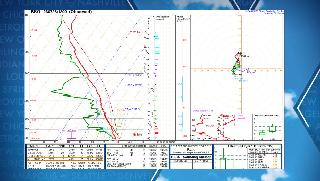
The National Weather Service in Brownsville said Tuesday they were already seeing hints the dust is around, but it remains well suspended above ground level.
NWS meteorologists pointed to data collected by a recent weather balloon launch that surveyed conditions in the atmosphere.
On the weather sounding, moisture levels significantly dropped off between the 18,000-30,000-foot levels, which was a clear indication to NWS meteorologists that the dust was likely around.
At this level, impacts on humans are limited, but it could enhance sky colors at sunrises and sunsets.
5 THINGS TO KNOW ABOUT THE SAHARAN DUST PLUME
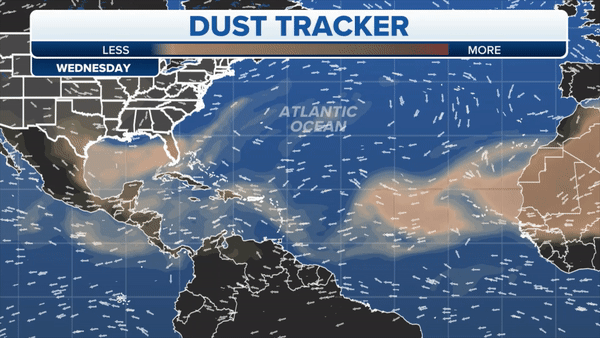
The FOX Forecast Center is monitoring the dust tracker that shows the plume possibly becoming thicker over the next 48 hours and mixing closer to the surface.
The result could be an increase in poorer air quality readings and even lead to a further reduction in precipitation chances, especially for communities around Brownsville, Corpus Christi, Houston and Galveston.
According to locals, the dust only makes its way to Texas a few times a year before weather patterns in the tropics make it virtually impossible for the particles to make the trip.
If air quality readings drop into the unhealthy stage, medical experts warn that eye, nose and throat irritations are possible, especially with sensitive groups.
The Texas Commission on Environmental Quality warns a combination of Saharan dust and smoke from Canadian wildfires is expected to persist over much of the state through the week, causing communities to reach at least moderate air quality readings.
The Air Quality Index ranges from 0 to 500, with lower values indicating cleaner air and any reading over 100 is considered to be unhealthy.
For the next several days, the TCEQ expects observations to fall between 50-100 on the AQI scale but warns if either the smoke or the dust is able to make it closer to the surface than anticipated, poorer air quality readings will be possible.
