


Detroit in the bull's-eye for severe storm threat as 36 million at risk from Great Lakes through Ohio Valley
A dangerous severe weather threat is building for the mid-Mississippi Valley stretching eastward into the southern Great Lakes on Wednesday.
Damaging wind gusts of at least 60 mph, the possibility for a few tornadoes, along with large hail with the more intense supercells are primary forecast hazards.
The storm's intensity will likely grow as it moves across the southern Great Lakes into the Lower Great Lakes by late in the evening. NOAA's Storm Prediction Center has included around 9 million in this area in a Level 3 out of 5 on its severe weather risk scale.
THE 5-POINT SEVERE THUNDERSTORM RISK CATEGORY SCALE EXPLAINED
Some of the larger populated areas in the enhanced risk area include cities like Detroit, Michigan, Toledo, Ohio, and Fort Wayne, Indiana.
"This is a pretty aggressive outlook," FOX Weather meteorologist Britta Merwin said. "The strongest risk for severe weather that we have had for the entire week. The kicker here is going to be the potential for strong, straight-line winds and, unfortunately, a tornado risk is there."
A level 2 threat of severe weather expands farther southwest, covering another 27 million in cities like Chicago, Indianapolis, Columbus and Cleveland, Ohio, and Milwaukee, Wisconsin. Scattered strong thunderstorms are possible here as well, and may include a few isolated storms that could reach severe criteria.
"The tornado risk is there," Merwin said. "It's 1 out of 5 (on the tornado threat scale). You don't want to take it lightly. So be prepared to take action to make sure that you have a place to go Wednesday afternoon when these thunderstorms arrive."
WATCH VS. WARNING: HERE ARE THE DIFFERENCES BETWEEN THESE WEATHER TERMS THAT COULD SAVE YOUR LIFE
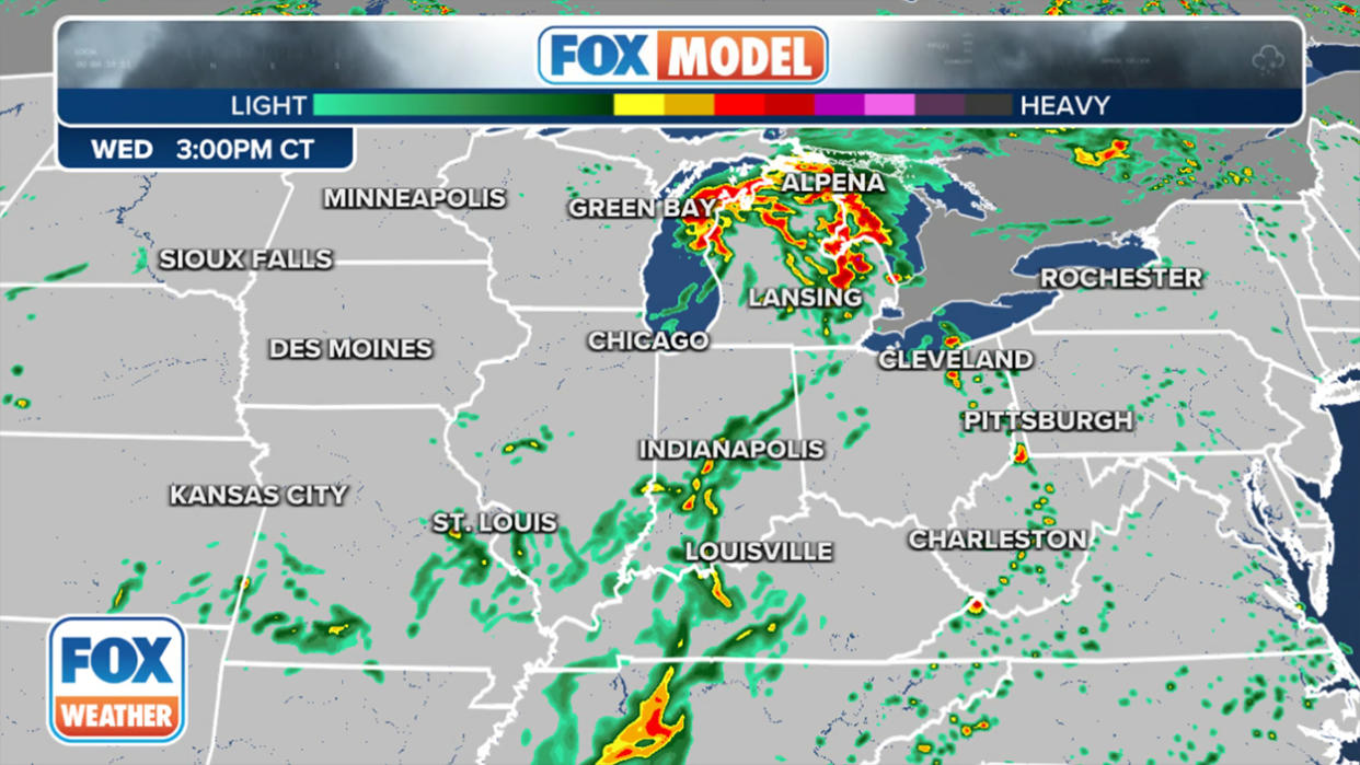
Looking at the FOX Model, Merwin said she expects sporadic Severe Thunderstorm Warnings during the morning hours Wednesday as a line of storms is tracked extending from Michigan and Wisconsin, all the way down into Illinois and Indiana.
"As this line continues to progress out towards the east, we get into the hot zone," Merwin said. "That's the area highlighted for 3 out of 5 risk around 3 p.m."
By 9 p.m., the pressure is taken off the Ohio Valley, but the storms will still me monitored as they progress through Pennsylvania and parts of New York.
By Thursday, widely scattered severe thunderstorms are expected across southern New England southward into portions of the Mid-Atlantic states.
You can download the FOX Weather app and track any potential showers or thunderstorms yourself using the built-in 3D Doppler radar feature, which you won’t find on any other weather app.
